This is a kind of working outline I wrote partly to give a friend some papers to wave around when correcting a misperception that Americans visiting South Sudan always seem to have
Torbjørn Tvedt, Colonial technicians. The Sudan veterinary service, 1898-1956 (PhD dissertation, University of Bergen, 1983), 2
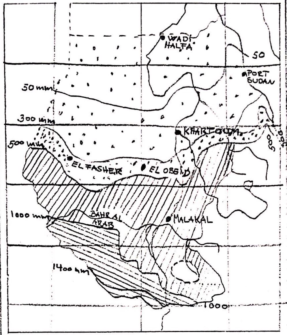
FAO’s recently published South Sudan Resilience Strategy for 2019-2021 includes a familiar comparison: ‘4 percent of land in South Sudan is cultivated although 95 percent of is suitable for agriculture.’1 These numbers, and the idea implicit in placing them side-by-side, are cited frequently and circulate widely.2 The percentage of land that is “suitable for agriculture” is variously put between 70 and “more than 95 percent” – itself a demonstration of how changeable a calculation we are dealing with here. Where did these figures come from, what do they mean?.
The claim that 70 percent of South Sudan is suitable for agriculture traces back to the work of the economist Xinshen Diao and her colleagues at the International Food Policy Research Institute.3 In 2009, Diao produced an assessment of development opportunities in Southern Sudan for the US Agency for International Development (USAID), which used ‘length of growing period’ as a proxy for ‘suitable for agriculture.’ Length of Growing Period (LGP) is a measurement of the moisture balance between precipitation (rain) and potential evapotranspiration (evaporation plus moisture released by plants) developed by the Agro-Ecological Zones (AEZ) project carried out by FAO in the late 1970s and early '80s. This approach defined the length of the growing period as the number of days during the year when soil moisture and temperature permits rain-fed crop growth: “the period (in days) during the year when precipitation exceeds half the potential evapotranspiration, plus a period required to evapotranspire up to 100 mm of water from excess precipitation (assumed) stored in the soil profile.”4
Determining the percentage of South Sudan's territory that is “suitable for agriculture” is a matter of collecting weather, land use, and soil data to calculate LGP. Plotted at intervals on a map, these moisture differences run in strips and the area of each strip can be calculated. In a subsequent version of their paper, Diao and her colleagues used an LGP of 180 days as a minimum threshold for “sufficient moisture and temperature conditions [to] permit crop growth.” They defined “high agricultural potential” as an LGP of more than 220 days and “medium potential” as an LGP between 180 and 220 days. By this measure, about 27.3 percent of land in South Sudan is located in areas with high agricultural potential (an LGP of more than 220 days) and another 41.5 percent in the medium potential areas (an LGP between 180 to 220 days).
So what does it mean then to say that about 70 percent of South Sudan is “suitable for agriculture”? Could Diao be saying that South Sudan’s land is underutilized and crop development schemes can be set up just any place? Apparently not. Diao used this figure as a starting point for a lesson about the need to relate the suitability for agriculture to human geography. Diao laid population densities over length of growing period (or, agricultural potential) to reveal those places where high (LGP > 220) or medium (LGP 180-220) “agricultural potential” overlapped with population densities of more than fifty people per square kilometer. You need labor to farm, after all. These areas, she suggested, would be best suited to intensive farming development. Her conclusions are modest: areas with more than 50 people per square kilometer and high or medium “agricultural potential” account for 4.8% and 7.8% of South Sudan’s land area—or just about 12 % of South Sudan in total.
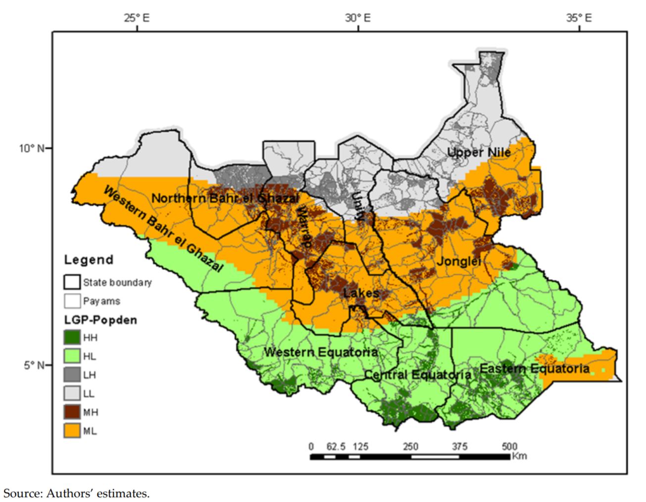
Map 3. Spatial patterns of agricultural potential and population density: HH: High agricultural potential /high-medium population density; HL: High agricultural potential/low population density; MH: Medium agricultural potential and high-medium population density; ML: Medium agricultural potential/low population density; LH: Low agricultural potential and high-medium population density; and LL: Low agricultural potential and low population density. Diao recommended prioritizing HH, HL, and MH areas for cropland development projects (Diao, et al., 2012, p. 144).
Taking this much more modest figure as a starting point, Daio and her colleagues created several models of cropland expansion to see how much more land could be brought under cultivation. To clear the way for the unimpeded cropland expansion which forms the basis of these models, Daio first eliminated factors that might complicate things. No one in this model has to worry about finding time and labor for farming. Daio supplies them all with plenty of tools for clearing land and cutting trees. People are free to open fields in the world that Daio has made for them, set free from the complications of land rights and public regulations, and unencumbered by family obligations or sick children. There are no problems of soil salinity or droughts or floods. There are no livestock in the model.
It must be admitted that this approach has its advantages. These are the usual advantages of models based on remote sensing data. It allows the analyst to skip past the problem of an “inability to verify the estimates at the ground level” (148) and to zoom out and look at the entire country. This is very useful for answering long-term and large-scale questions; it allows planners to guess what to expect in five or ten years’ time and to plan for it. Daio’s “moderate expansion scenario” sees a 2.3-fold increase in cropland; an “aggressive scenario” gives a 3.5-fold increase. In 2012, many saw these numbers as a justification for encouraging private land acquisition and investment, as a way to diversity an oil-dependent economy and to improve food security. More recently they’ve been cited in support of programs that encourage rural cropland expansion.
A sceptical view is that the popularity of these statistics stems from the justification that they provide for extending the reach and purpose of foreign agronomic expertise. It allows one to skip over awkward questions about whether supporting cropland expansion at the expense of animal husbandry might link low-wage labor to humanitarian aid while also increasing farmers' vulnerability to flooding by pushing their activities onto more and more marginal land.
Saying that 95 percent (or, even just 70%) of South Sudan is suitable for agriculture, (while only 4% is cultivated), is a bit misleading and may lead us away from important questions. What do things look like “at the ground level”? In 1938, Captain J.M. Stubbs, the District Commissioner at Aweil, and C.G.T. Morison, a Reader in Soil Science at Oxford who carried out soil surveys in Sudan, considered a wide swathe of land fanning out east from Aweil, one of the High Potential/High Population areas identified by Diao. “Casual and indifferent cultivators are common in Africa,” Stubbs and Morison wrote, evoking a pejorative image of laziness and a justification for outside intervention popular in the 1930s, “and the vast area of land available has not tended to make them careful of the natural resources of the soil.” But, Stubbs and Morison caution, “here in the flood plains of the Upper Nile conditions are different, and the area of land which is available for the growing of crops too small” (251-2).6 In order to farm, residents of the Upper Nile had found it necessary “to devise some kind of cultivation that would ensure a reasonable crop and also to invent some way of keeping sufficiently fertile to produce crops indefinitely in the same soil. This [has been] achieved with great success and by resort to a complete and conservative system of mixed husbandry” (252). Cattle graze during the day and, at night, are tethered close together near people’s houses. Cattle, sheep, and goats carry soil from pastures to settlements, where the concentration of dung and urine build up little islands of raised and fertile land around homesteads and cattle-camps that have been kept under cultivation for generations. And what of those vast expanses of grassland you see while flying over the country? It isn’t wasteland. These pastures are cleared each year of shrubs and thorns with fire, which livestock keepers use to cultivate fresh forage for their animals in the fashion that farmers elsewhere use the plough.
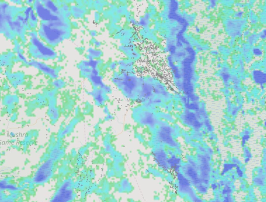
Settlement and flood risk in a Medium agricultural potential and high-medium population density.7
But even centuries of terraforming by the action of livestock and fire cannot wholly safeguard crops against the region’s erratic rainfall and flooding. During many good harvest years, most people’s food was grown within walking distance of their homes. But during bad years, people have long relied on networks of reciprocity and obligation, far-flung multi-generational ties of mutual aid that enabled them to obtain cattle and grain during times of shortage. Grain reserves for famine were held in in-laws’ granaries. The historian Douglas Johnson has described how people in the Upper Nile adapted themselves to perils of farming crops in a region with such uncertain rainfall and seasonal flooding and droughts by knitted together a ‘common economy’ out of networks of matrimonial alliances and friendship. These networks spread the risks of erratic flooding and drought and animal disease across a wide region and carved channels of connection and mutual aid across divisions of locality and language.8
Of course, all these interconnections—between crop systems and livestock, marriages, population and labor—is very complicated. In the optimism of the late 1970s and early 1980s, when the Addis Ababa Agreement encouraged the kind of long-term planning that big development schemes require, agronomists in Southern Sudan set themselves the task of puzzling it out. Systems research, inspired by the farming system research approach (and the new popularity of personal computers), was carried out alongside the Pengko (or Penkou) Plains Pilot Project, in the vicinity of Bor. It attempted to model all this interconnection and emphasized the problems of “feedback mechanisms, [which] may constitute limitations to a further improvement of the situation or even cause it to deteriorate” (Bontkes, p. 2), or what we would today call ‘unintended consequences.’ This work produced an impressive array of flow diagrams to show (in case anybody doubted it) that in rural South Sudan everything is connected to everything else. Nowadays the project is seen as a dead-end; the consensus among those who remember it at all is that it failed to accomplish much of anything.9
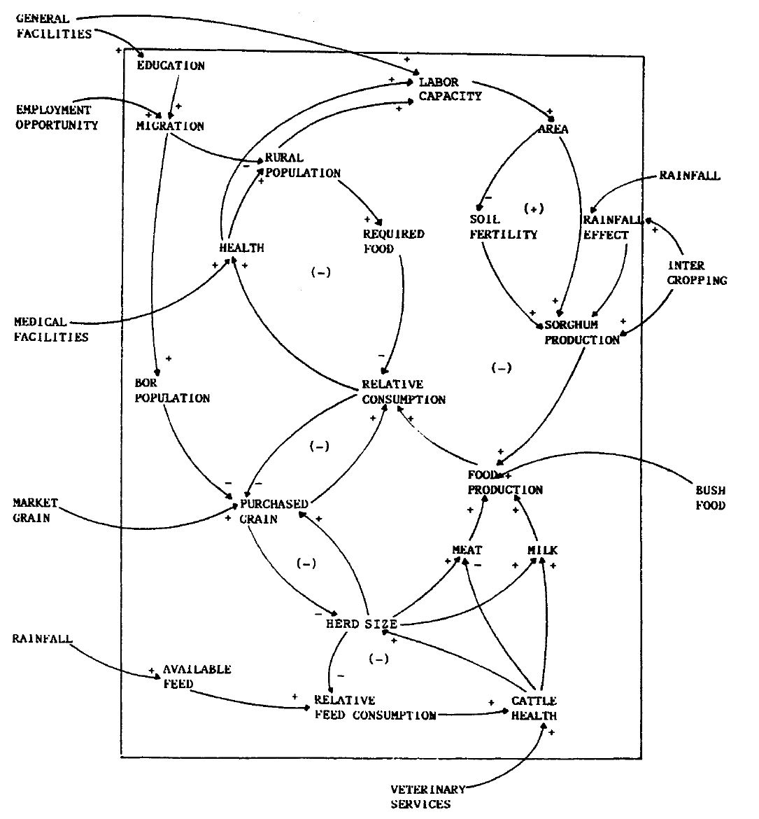
Tjark E. Struif Bontkes, 'Dynamics of rural development in southern Sudan', System Dynamics Review 9, no. 1 (1993), 3 fig. 1
This is all rather a shame. Humanitarian and development workers have drifted off to other concerns but the same problems raised by Stubbs and Morison, Johnson, and Bontkes keep re-emerging. Despite the apparent urgency of questions about ‘resilience,’ ‘conflict sensitivity,’ and ‘unintended consequences,’ Bontkes’ work had no real successors in South Sudan. Emergency program planners rarely welcome complicated analysis of the interactions between crop interventions, veterinary services, medical care, roads, schools, and water projects; and there are those who would question whether there’s much of a point in trying to map out these interactions at all in the absence of structures to coordinate such ‘cross-sectoral programming’ and the activities of so many NGOs. Most of this has simply been left to ‘local authorities’ to sort out. But there is a point to asking how things relate to each other. Especially in famine-prone areas, where people move around and combine multiple livelihoods, oscillating over the course of a year from cultivation to herding to fishing or making charcoal or collecting timber for markets or hiring themselves out as casual laborers. Labor is often the last commodity that can be sold during the hardest times, and labor prices often collapse during famines. Cash- and food-for-work programs, say for dyke-building, divert hands from farmwork and child care and, sometimes, run the risk of alienating land. It is all very well to do cropland development, Stubbs and Morison warned in 1938, but it bears remembering that for agro-pastoralists neglecting livestock can also mean losing land rights and fertilizer and labor.10
Among those factors that have most concerned observers of South Sudan in more recent years are land alienation and the disruption of land-right systems. A few years back, David Deng pointed out that the understanding of underutilization implicit in the placement of food insecurity statistics alongside claims that 95-or-somesuch-percent of South Sudan is suitable for agriculture has long provided a justification for the transfer of large tracts of land to private individuals and companies.11
This has a long history, going back to the 1905 Anglo-Egyptian colonial Land Settlement Ordinance and the 1925 Land Settlement and Registration Ordinance (‘all waste, forest, and unoccupied land shall be deemed to be the property of the government, until the contrary is proved’), whose designation of ‘unoccupied land’ overlooked long-term fallow rotations and the rights of herders and other occasional and seasonal users. In the 1970s, when loans for development projects encouraged the expansion and intensification of export-oriented mechanized agricultural schemes, the Unregistered Land Act of 1970 allowed the government to lease large tracts of land to wealthy merchants. “Since virtually none of the lands held by communities in the peripheries of the country had been registered with the central lands registry in Khartoum,” Deng (2011:8-9) observed, “the [Unregistered Land Act] effectively eliminated any legal claims that communities may have had to their community lands” and allowed the government to grant access to foreign companies. In 1974, Chevron began prospecting for oil and a new Sudan Penal Code was passed, partly, to justify impunity in the use of arbitrary violence by the designation of ‘customary landholders’ as trespassers and whole regions as terra nullius—and their inhabitants, lawless squatters.
Forty years later, Timm Sureau described how, when several women were displaced by an expansion of the UNMISS compound in Torit, a Director of Planning characterized the women as “illegal owners” of the land: “[it] is very easy to solve…which one would you prefer: UNMISS or these three local women” (148)? A County Commissioner had told the women: “just go two or three kilometers [outside of town]. There is enough land there” (150).12 In more recent years, researchers have described how well-connected individuals have used access to cash from international NGOs or the UN to buy plots or secure individual claims on clan lands in court; others have noted the risks of large cash for work projects, which not only lift land from ‘community ownership’ and place it in the hands of individuals who sign MoUs, but also entrench wartime patterns of labor control.13
More recently, Nicki Kindersley has written about how rural livelihood programs run the risk of helping to “consolidate elite economic power at the expense of the continued impoverishment of the majority,” and that these dangers have not always been avoided.
"The South Sudan government is keen to ruralise its population in areas it controls to benefit from cheap farm labour and a recruitment pool of poor young men. People who were transported back to rural ‘home areas’ during the 2008-2012 IOM facilitated returns process, particularly those with no funds or family networks to rely on (like urbanised young refugee women with dependent children), had little option but to depend on daily low-waged farm labour on upper-class residents’ large farms, or poorly-paid military work in the army or paramilitary groups" (Kindersley 2019, 4).
Ruralizing populations and limiting urbanization, where new political movements often begin, is a useful way to limit access to education and information, and to create a pool of easily exploited workers for agricultural schemes and armies.14
To say that 70 percent of South Sudan is suitable for agriculture is to say that the country is warm and sunny and that it rains a lot. This is true. It also distracts from more pressing matters.
Footnotes
1 Emphasis in original. Food and Agriculture Organization (FAO) of the United Nations, South Sudan Resilience Strategy 2019–2021: Working across the humanitarian-peace-development nexus for resilience and food security (FAO: 2019)
2 IFPRI, ‘South Sudan’s agriculture minister speaks at IFPRI’ (23 October 2012), quoting Minister of Agriculture H.E. Dr. Betty Achan Ogwaro; Marleny Arnoldi, ‘South Sudan invites investment in agriculture, mining, oil,’ Creamer Media’s Engineering News, 25 April 201; JICA, ‘South Sudan: Project for Comprehensive Agricultural Development Master Plan (CAMP); UNDP, ‘Factsheet: Climate Change, Food Insecurity and Resilient Livelihoods in South Sudan’ (29 June 2017); FAO, Seed System Security Assessment: Southern Sudan November-December 2010 (March 2011). One can multiply examples endlessly. For 90 percent, see: Republic of South Sudan Ministry of Agriculture & Forestry, ‘Emergency Food Crisis and Response Project (EFCRP) Environmental and Social Assessment Report’ (2013); for lower figures, see Diao et al. 2009 and 2012. In his doctoral dissertation, John Garang cited a 1973 FAO estimate suggesting that 152,322,000 feddans in the Autonomous Southern Region were “land suitable for agriculture.” This figure is about 100 percent of the present state of South Sudan. John Garang de Mabior, Identifying, selecting, and implementing rural development strategies for socio-economic development in the Jonglei Projects Area, Southern Region, Sudan (PhD dissertation, Iowa State University, 1981), pp. 14-15.
3 Xinshen Diao, Vida Alpuerto, Renato Folledo, C. Guvele and Liangzhi You, Assessing Food Security and Development Opportunities in Southern Sudan (Washington, D.C.: IFPRI, 2009).
4 Food and Agriculture Organization (FAO) of the United Nations, Report on the Agro-ecological Zones Project, Vol. 3 (FAO: Rome, 1981), 35
5 Xinshen Diao, Liangzhi You, Vida Alpuerto and Renato Folledo, ‘Assessing Agricultural Potential in South Sudan – A Spatial Analysis Method’ in Application of Geographic Information Systems, Bhuiyan Monwar Alam, ed. (INTECH Open Access, 2012). This method will get you up to about 80%.
6 Captain J.M. Stubbs and C.G.T. Morison, ‘The Western Dinkas, their land and their agriculture,’ Sudan Notes and Records 21, no. 2 (1938), 251-265. Similar conclusions were reached by IMPACT-REACH, BRACED Flood Impact Assessment Greater Bahr el Ghazal, South Sudan (IMPACT-REACH, August 2016)
7 This overlay is from REACH. Relying on remote sensing data had some very real risks. Estimates of flood exposure based on the Global Surface Water Explorer7, for instance, underestimate the extent of periodic flooding in South Sudan. Mott MacDonald, Assessment for the Bor Flood Control Initiative Scoping study (2019), 9-10. Douglas H. Johnson, ‘Reconstructing a history of local floods in the Upper Nile Region of the Sudan,’ The International Journal of African Historical Studies, 25, no. 3 (1992), 607-649. The global surface water explorer is available here.
8 Douglas H. Johnson, ‘Political Ecology in the Upper Nile: the Twentieth Century Expansion of the Pastoral ‘Common Economy’,’ The Journal of African History 30, no. (1989), pp. 463-486.
9 George Tombe Lako, ‘The Impact of the Jonglei Scheme on the Economy of the Dinka,’ African Affairs 84, no. 334 (1985), pp. 15-38. ‘Gama heeft een droom, namelijk een tweede Gezira Scheme in zuid-Soedan, in de Pengko vlakte ten oosten van Bor.’ Sjoerd Zanen, Tong Mabior: In het gebied van de Boven-Nijl – tussen verleden en toekomst (African Studies Centre Leiden, 2018), 32. Zanen describes how Dr. Gamma Hassan, Minister of Agriculture in the HEC, hoped to establish a “second Gezira Scheme in southern Sudan” by replacing cotton with sorghum on the Pengko Plain near Bor and suggested the idea to receptive Dutch government officials. (The Dutch road construction company De Groot (from Dordrecht) is memorialized in Bor by a number of place names. I sent inquiries about the Pengko Plain project to Dutch embassies in Juba and Khartoum. No one there had ever heard of it.) Somewhat ironically, Sudan’s largest agricultural schemes, “breadbasket” projects like the Gezeria scheme and Managil extension, were located in areas that were by Diao’s measure, totally unsuitable for agriculture.
10 For a discussion about the risks of neglecting livestock programs, and how donor investment in livestock has failed to reflect the priorities of many South Sudanese (specially compared to spending on direct food assistance), see Naomi Pendle, Food Security, Access and Conflict Sensitivity: What opportunities do livestock offer in South Sudan? (CSRF Briefing Note, 2017
11 David K. Deng, ‘Land belongs to the community’: Demystifying the ‘global land grab’ in Southern Sudan (Sussex: The Land Deal Politics Initiative, 2013).
12 Timm Sueau, ‘Contested resources: Common practices, means of exclusion,’ in Forging Two Nations: Insights on Sudan and South Sudan, Elke Grawert, ed. pp. 143-159, (OSSREA, 2013).
13 Nicki Kindersley and Joseph Diing Majok, Monetized Livelihoods and Militarized Labour in South Sudan’s Borderlands (RVI, 2019)
14 Nicki Kindersley, Returns and Peace in South Sudan: Challenges, opportunities and the way forward (Conflict Sensitivity Resource Facility, 2019)